
Wigan bridge, Tauwhareparae Road, Tolaga Bay. Source: Tairawhiti Civil Defence
Rain has eased and river levels have dropped in the Tolaga Bay area, but twelve local roads remain closed and eleven bridges in the area remain a concern.
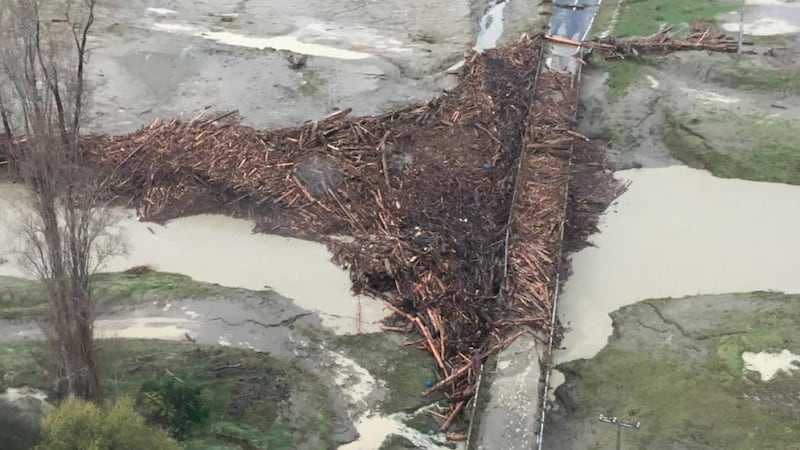
Tairawhiti Roads journey manager Helen Harris says the most significant concern is the Wigan Bridge on the Tauwhareparae Road out of Tolaga Bay.
“The bridge has moved at least 30cm and is twisted. As a result, Tauwhareparae Road from Paroa Road onward will be closed for at least two weeks. Engineers will have more information to us later today.”
Wigan bridge, Tauwhareparae Road, Tolaga Bay. Source: Tairawhiti Civil Defence
The other ten bridges are the Mangatokerau Bridge, Paroa Road; a bridge in Andrews Road; Waiomoko Bridge on SH35 near Whangara; Mangaheia Bridge Nos 1-5 and Matai Bridge on Tauwhareparae Rd; and Seymours Bridge, Waiomoko Road, inland of Whangara.
“There are 61 bridges in the affected catchment area that will need to be inspected progressively over the coming days,” says Harris.
Clearing the debris away from underneath the bridges was no easy task with high river levels and difficulty in getting machinery in place, she says.
“We are working with council’s environmental team to see where we can initially deposit all the debris. We can’t just tip it back into the river.”
Roads
Six crews of contractors are checking on other roads in the affected area but no other road closures are planned.
Closed roads are the Paroa, Mangatokerau, Pa, Waiomoko, Arakihi, Kiore, Anaura Bay, Kaiaua, Waihau Bay, Glenroy, Tauwhareparae and Takapau roads.
Mata Road is an accessway and will remain open.
Meanwhile, a dead horse sighted was also sighted in the Waimata River under the William Pettie Bridge.